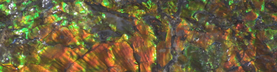
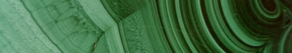

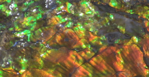
Malachite


CANADIAN ROCKIES,
AMMONITES & FOSSILS
In 2012 I travelled to the adjoining Provinces of British Columbia and Alberta in western Canada. The region is rich
geologically and contains many gem & mineral resources. The photos below summarise some of the features which will
hopefully be of interest to gem/mineral/fossil enthusiasts.
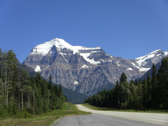
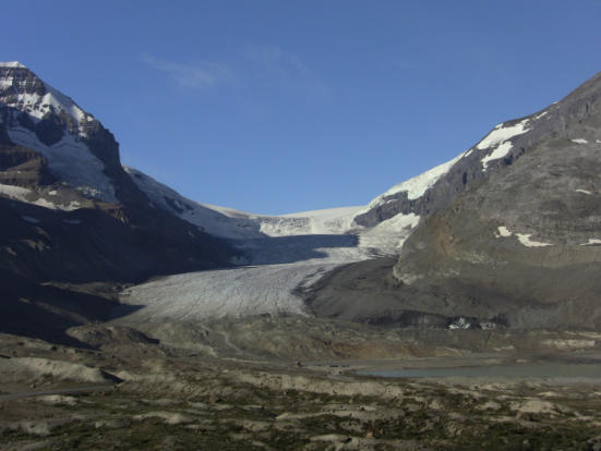
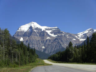
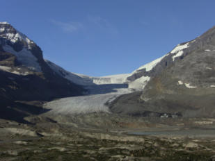
Trans-Canada
highway, B.C.
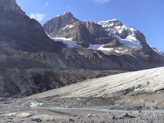
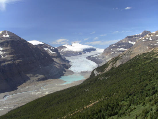
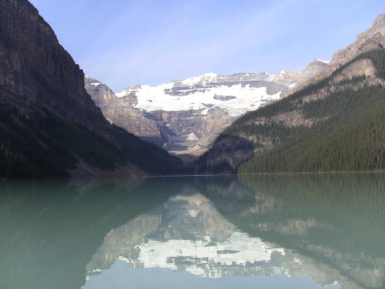
Mt Robson, on the trans-Canada highway, B.C. The highest mountain in the Canadian rockies. The Athabasca Glacier is part of the Columbia Icefield, which covers an area of about 200 square km. The glacier flows down hill at around 15 - 20 m per year at the lower end, but at up to 127 m per year in the upper part. At the lower end of the Athabasca Glacier you can see on the left side part of the ‘lateral moraine’ deposited by the glacier. Lateral moraines consist of rock debris and sediment that have come loose from the walls beside a valley glacier and have built up in ridges along the sides of the glacier. The Saskatchewan Glacier, showing the lateral moraine on the LHS of the valley and the glacial till (rock & soil carried by the glacier) on the valley floor downstream of the glacier. Lake Louise, in the Rocky Mountains, showing several glaciers in the distance. I n the city of Canmore, Alberta, there is an Ammonite factory which I visited. The pictures in this slide show some of the Ammonite specimens and gem material on display. THE ROYAL TYRELL MUSEUM OF PALAEONTOLOGY is located in Drumheller in Alberta. This museum contains a large number of spectacular dinosaur skeletons recovered in the region. It provides an excellent insight into the wide range of fossils which have been discovered in Alberta, varying from the enormous Tyrannosaurus Rex to the lovely Ammonites. DINOSAUR PROVINCIAL PARK South of the Royal Tyrell Museum is Dinosaur Provincial Park, located in the ‘Badlands’ (a dry eroded area which contains extensive fossil deposits). In Dinosaur Provincial Park, there are many areas where large numbers of fossils are found together, covering large areas. It is believed that the large numbers of dinosaur fossils found in this area may be the result of a natural disaster such as a tsunami, as the area was next to an ancient inland sea at the time!


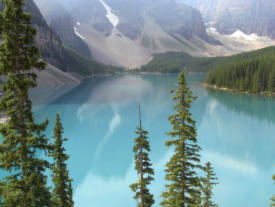
The photo to the left shows you a view of Moraine lake,
located near Lake Louise in the Canadian Rockies. It has
formed behind a ‘terminal moraine’ as a result of glacial
action.
The photo to the left shows you a view of Moraine lake,
located near Lake Louise in the Canadian Rockies. It has
formed behind a ‘terminal moraine’ as a result of glacial
action.
While driving through Washington State, along hwy 90, I
visited Ginkgo Petrified Forest state park. At a local rock
shop I got to see some of the material which had been
collected from the area. Quite spectacular. See the four
photos to the left.
THE HAWAII VOLCANOES
NATIONAL PARK
is located on the island of Hawai’i, or the ‘big island’.
The park includes part of Mauna Loa volcano and
also contains Kilauea volcano, two of the most
active volcanoes in the world. Over the last 200
years they have erupted, on average, every 2 or 3
years. Most eruptions of these volcanoes are non-
explosive and the volcanoes are monitored by the
USGS (US Geological Survey).
Hawaiian lava is highly fluid and mainly composed
of basalt. This fluidity reduces the likelihood of
explosive eruptions. Most eruptions begin with lava
fountains spouting from a series of fissures. In 1959
a lava fountain some 580 m high was observed.
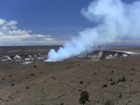
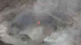
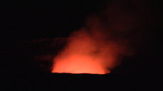
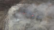
ABOVE AND LEFT:
KILAUEA volcano showing steam from the vent. At
night the glow of the lava is clearly visible.
LEFT:
This photo shows Kilauea volcano at night. The lava
lake in the vent causes the glow in the gases
escaping from the vent. This is the same crater
shown above left.
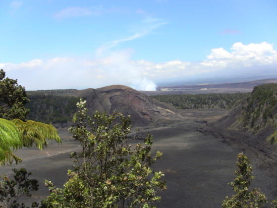
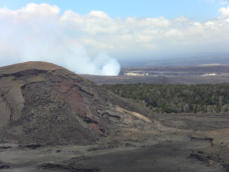
L: Looking over the crater of Kilauea Iki, showing
the once-molten lake of lava on the crater floor.
Kiauea’s vent is visible in the background. Kilauea
means “spewing”, which is what happened on
14/11/1959 when a curtain of lava burst from a 800
m long fissure in the crater wall. Over five weeks
molten rock flooded the crater, creating a lake of
lava that rose halfway up the crater walls (some
120m high, approximately 86 million tonnes of lava).
Note the cinder cone, Pu’u Pua’I, in the centre of the
photo. This cone did not exist prior to the 1959
eruption. The reddish-brown cavity at the base of
this cone was the main vent from which lava
erupted, surging some 580 m above the vent. [See
the photo below left] During one eruptive episode
spatter (blobs of molten rock) up to one metre in
diameter shot across the crater landing near where
this photo was taken!
Note the main vent (reddish-brown) at the base of
the cone. There are people walking across the floor
of the crater which provides an indication of the size
of the crater.
A small part of the floor of the crater of Kilauea Iki.
When the vent stopped erupting (after being
submerged by the lava lake) the molten lava
drained back into the vent. As this occurred the lava
crust subsided and broke in to the surface you see
today. There are still active steam vents on the
crater floor.
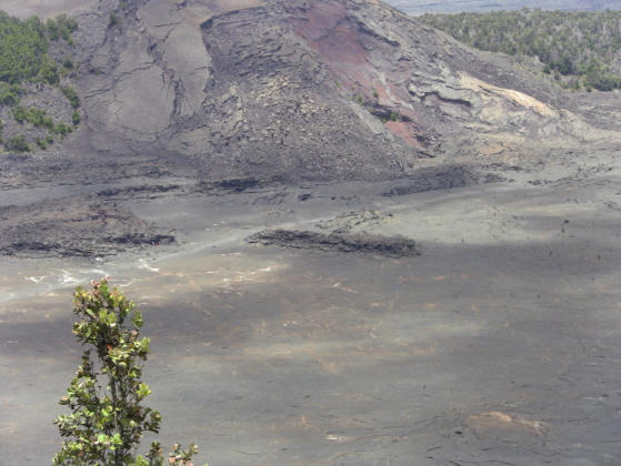
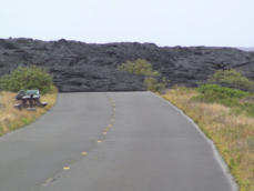
The road was closed by the lava flow in 2003.
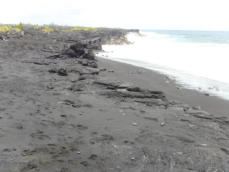
A black sand beach formed from the lava flows. You
can also visit green beaches (olivine) and white
beaches (coral) on the ‘big island’.
Vegetation is slowly returning to the lava flows.
Initially lichen and mosses appear, then small ferns
in the cracks in the lava, then larger plants.
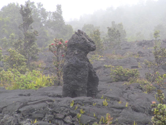
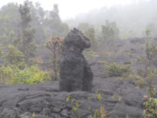
Note the interesting lava shape in the middle of the
picture.
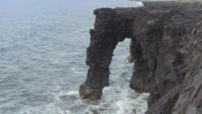
‘Holei’ Sea Arch, some 18 m high, where the lava
flows are being eroded by the sea.
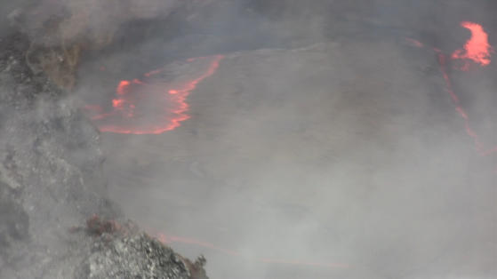
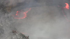
The two photos left, plus the one below, are of the
Moku’aweoweo caldera at the summit of Mauna Loa
on the island of Hawai’i (the ‘big island’). The
summit is 4169 m above sea level. These photos
were taken from a helicopter in misty/rainy
conditions, typical of the area. They clearly show the
molten lava in the crater.


HAWAII VOLCANOES NATIONAL PARK


- index
- contact-us
- club activities 2026-
- club activities 2021 -
- Club activities 2021 --a
- Club activities 2021 --b
- club activities 2019_20
- club activities 2017_18
- club activities 2016
- club activities 2015_2014
- club activities 2013_2012_2011
- club activities 2010_2009_2008
- club activities 2007_2006_2005_2004
- club shows 2004_2016
- club shows 2018 _
- office bearers and life members
- club history
- links
- fossicking in south west victoria
- places you might like to visit
- europe 2014
- usa_canada_gems_geology
- Canada_hawaii_gems_geology
- gem_mineral collections
- some australian gems
- Gem articles
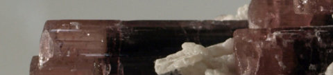

Elbaite crystals


CANADIAN
ROCKIES,
AMMONITES &
FOSSILS
In 2012 I travelled to the adjoining Provinces of British Columbia and
Alberta in western Canada. The region is rich geologically and contains
many gem & mineral resources. The photos below summarise some of
the features which will hopefully be of interest to gem/mineral/fossil
enthusiasts.

Trans-Canada
highway, B.C.
Mt Robson, on the trans- Canada highway, B.C. The highest mountain in the Canadian rockies. The Athabasca Glacier is part of the Columbia Icefield, which covers an area of about 200 square km. The glacier flows down hill at around 15 - 20 m per year at the lower end, but at up to 127 m per year in the upper part. At the lower end of the Athabasca Glacier you can see on the left side part of the ‘lateral moraine’ deposited by the glacier. Lateral moraines consist of rock debris and sediment that have come loose from the walls beside a valley glacier and have built up in ridges along the sides of the glacier. The Saskatchewan Glacier, showing the lateral moraine on the LHS of the valley and the glacial till (rock & soil carried by the glacier) on the valley floor downstream of the glacier. Lake Louise, in the Rocky Mountains, showing several glaciers in the distance.


In the city of Canmore, Alberta, there is an Ammonite factory which I visited. The
pictures in this slide show (above) show some of the Ammonite specimens and gem
material on display.
THE ROYAL TYRELL MUSEUM OF
PALAEONTOLOGY
is located in Drumheller in Alberta. This museum contains a large number of
spectacular dinosaur skeletons recovered in the region. It provides an excellent
insight into the wide range of fossils which have been discovered in Alberta, varying
from the enormous Tyrannosaurus Rex to the lovely Ammonites.
DINOSAUR PROVINCIAL PARK
South of the Royal Tyrell Museum is Dinosaur Provincial Park, located in the
‘Badlands’ (a dry eroded area which contains extensive fossil deposits).
In Dinosaur Provincial Park, there are many areas where large numbers of fossils
are found together, covering large areas. It is believed that the large numbers of
dinosaur fossils found in this area may be the result of a natural disaster such as a
tsunami, as the area was next to an ancient inland sea at the time!
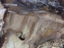
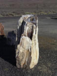
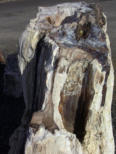
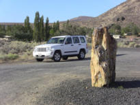

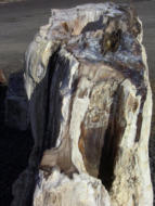
While driving through Washington State, along hwy 90, I visited Ginkgo Petrified
Forest state park. At a local rock shop I got to see some of the material which had
been collected from the area. Quite spectacular. See the four photos to the below.
The photo (bottom left) shows you a view of Moraine lake, located near Lake Louise
in the Canadian Rockies. It has formed behind a ‘terminal moraine’ as a result of
glacial action.
HAWAII VOLCANOES
NATIONAL PARK
THE HAWAII VOLCANOES
NATIONAL PARK
is located on the ‘big island’. The park
includes part of Mauna Loa volcano and
contains Kilauea volcano, two of the most
active volcanoes in the world. Over the last
200 years they have erupted, on average,
every 2 or 3 years. Most eruptions are non-
explosive and the volcanoes are monitored
by the US Geological Survey.
Hawaiian lava is highly fluid and mainly
composed of basalt. Most eruptions begin
with lava fountains In 1959 a lava fountain
some 580 m high was observed.
TOP TWO PHOTOS: KILAUEA
volcano showing steam from the
vent. At night the glow of the lava is
clearly visible. The lava lake in the
vent causes the glow in the gases
escaping from the vent.
L: Looking over the crater of Kilauea Iki,
showing the once-molten lake of lava on
the crater floor. Kiauea’s vent is visible
in the background. On 14/11/1959 a
curtain of lava burst from a 800 m long
fissure in the crater wall and flooded the
crater, creating a lake of lava some
120m high).
Note the cinder cone, Pu’u Pua’I, in the
centre of the photo. This cone did not
exist prior to the 1959 eruption. The
reddish-brown cavity at the base of this
cone was the main vent from which lava
erupted, surging some 580 m above the
vent. There are people walking across
the floor of the crater which provides an
indication of the size of the crater.
A small part of the floor of the crater of
Kilauea Iki. When the vent stopped erupting
(after being submerged by the lava lake)
the molten lava drained back into the vent.
As this occurred the lava crust subsided
and broke in to the surface you see today.
There are still active steam vents on the
crater floor.
The road was closed by the lava flow
in 2003.
A black sand beach formed from the
lava flows. You can also visit green
beaches (olivine) and white beaches
(coral) on the ‘big island’.
Vegetation is slowly returning to the
lava flows. Initially lichen and mosses
appear, then small ferns in the cracks
in the lava, then larger plants.
Note the interesting lava shape in the
middle of the picture.
‘Holei’ Sea Arch, some 18 m high,
where the lava flows are being
eroded by the sea.
The two photos left, plus the one
below, are of the Moku’aweoweo
caldera at the summit of Mauna Loa
on the island of Hawai’i (the ‘big
island’). The summit is 4169 m above
sea level. These photos were taken
from a helicopter in mist/rain. They
show the molten lava in the crater.


- index
- contact-us
- club activities 2026-
- club activities 2021 -
- Club activities 2021 --a
- Club activities 2021 --b
- club activities 2019_20
- club activities 2017_18
- club activities 2016
- club activities 2015_2014
- club activities 2013_2012_2011
- club activities 2010_2009_2008
- club activities 2007_2006_2005_2004
- club shows 2004_2016
- club shows 2018 _
- office bearers and life members
- club history
- links
- fossicking in south west victoria
- places you might like to visit
- europe 2014
- usa_canada_gems_geology
- Canada_hawaii_gems_geology
- gem_mineral collections
- some australian gems
- Gem articles


